ၾၢႆႇ:Kernkraftwerk Saporischschja.JPG

သႅၼ်းတႃႇတူၺ်းလူင်ႈၼႃႈ: 800 × 578 ၽိၵ်ႉသႄႇလ်. resolutionsတၢင်ႇဢၼ် : 320 × 231 ၽိၵ်ႉသႄႇလ် | 640 × 462 ၽိၵ်ႉသႄႇလ် | 1,024 × 739 ၽိၵ်ႉသႄႇလ် | 1,280 × 924 ၽိၵ်ႉသႄႇလ် | 2,560 × 1,849 ၽိၵ်ႉသႄႇလ် | 3,790 × 2,737 ၽိၵ်ႉသႄႇလ် ။
ၾၢႆႇငဝ်ႈတိုၼ်း (3,790 × 2,737 pixels, တၢင်းလဵၵ်ႉတၢင်းယႂ်ႇ ၾၢႆႇ: 4.4 MB, ယိူင်ႈ MIME: image/jpeg)
ၵႂၢမ်းယေႃး
| ၶေႃႈသပ်းလႅင်း |
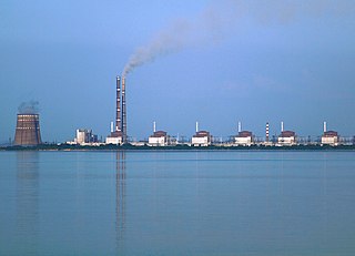
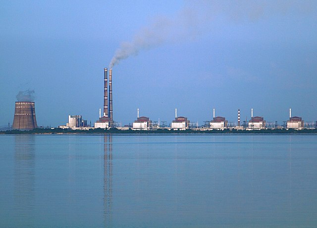
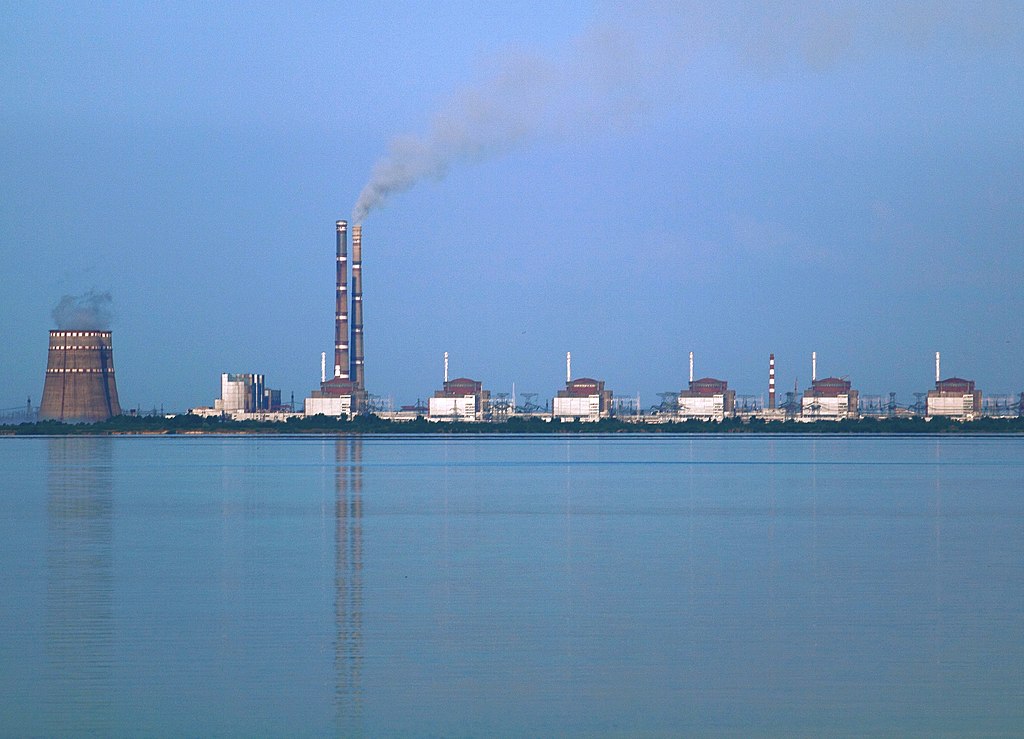
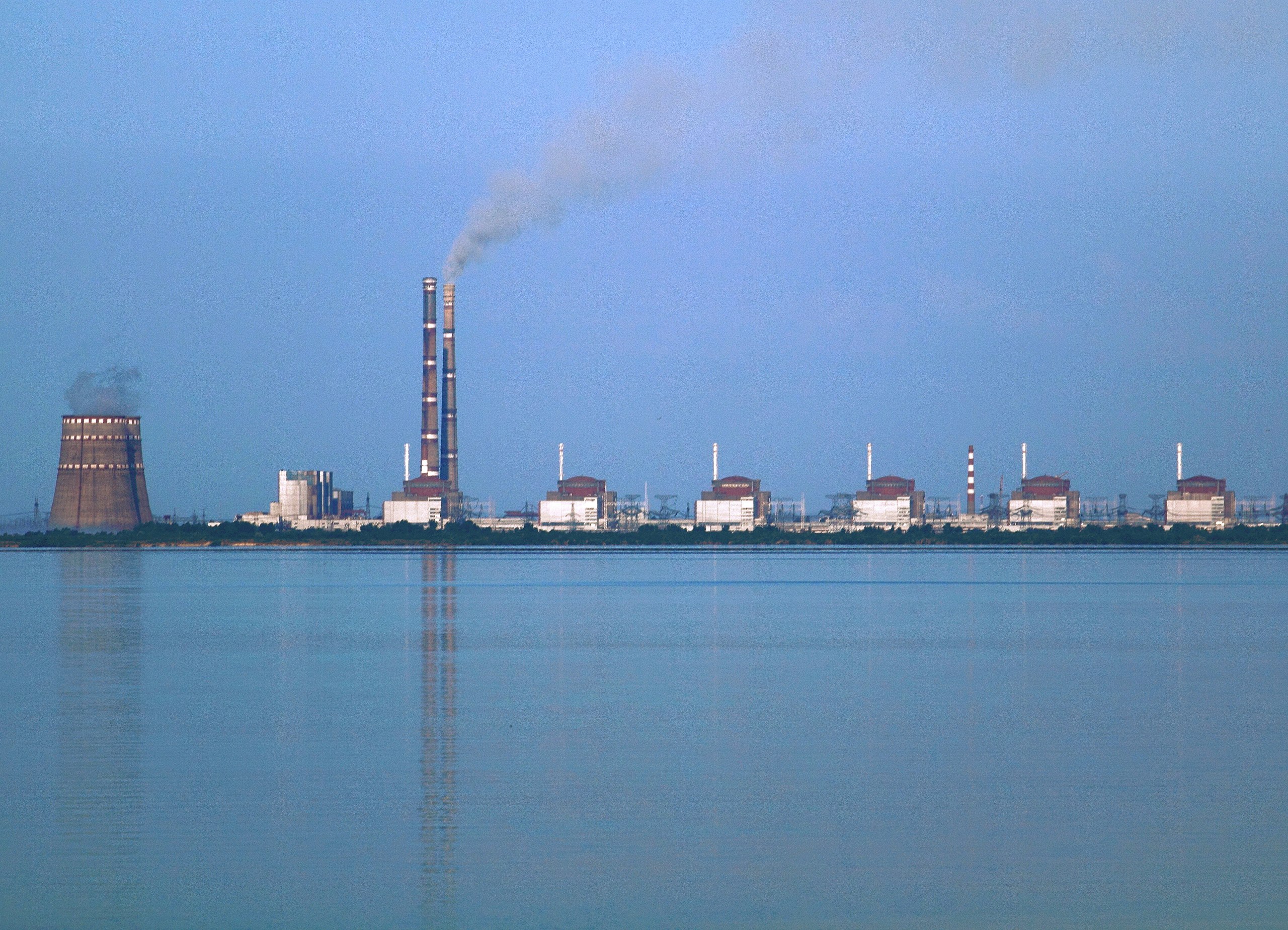
English: Two power stations at Enerhodar, about 50 km from Zaporozhye in Ukraine, viewed from across the Kakhovka Reservoir on the river Dnieper. Photo taken from the "Nikopol" shore. The nearer power station is Zaporizhzhia Nuclear Power Plant, the biggest nuclear power station in Europe, consisting of two cooling towers (one largely obscured by the other) at the left and 6 VVER reactor buildings. The large building between the cooling towers and the reactors, and the two tall smokestacks, are at the Zaporizhzhia thermal power station about 3 km beyond the nuclear plant.
Deutsch: Größtes Atomkraftwerk Europas; etwa 50 km von der Großstadt Saporischschja entfernt. Bild aus Westen, von der Stadt Nikopol am gegenüberliegenden Ufer des Dnjepr aufgenommen, auf sechs baugleich erscheinende AKW-Blöcke, links Kühltürme, zwei hintereinander stehende Kesselhäuser und zwei 320 m hohe Schlote vom benachbarten Wärmekraftwerk. Die hohen Schornsteine und die Kesselhäuser stehen, aus dieser Perspektive gesehen, etwa 2 km hinter (=östlich von) Block 6 und die zwei Kühltürme etwa 1 km vor dem Kernkraftwerk, also 3 km vom Wärmekraftwerk entfernt..
Русский: Крупнейшая атомная электростанция в Европе; 50 километров от города Запорожье, Украина. Фото с противоположного, "Никопольского" берега Днепра
Українська: Найбільша АЕС Європи у місті Енергодар, 50 км від Запоріжжя. Фото з протилежного, "нікопольського" берега Дніпра |
| ဝၼ်းထီႉ | |
| ငိူၼ်ႈငဝ်ႈတိုၼ်း | ၵၢၼ်ၶွင်တူဝ် |
| ၽူႈတႅမ်ႈလိၵ်ႈ | Ralf1969 |
| Openstreetmap entry | Link to Openstreetmap |
| Object location | | View this and other nearby images on: OpenStreetMap |
|---|
ဝ်ႂ
I, the copyright holder of this work, hereby publish it under the following licenses:

|
ပၼ်ၶႂၢင်ႉ တႃႇတေ ထုတ်ႇဢဝ်၊ ၽႄႈတိုၼ်း လႄႈ/ဢမ်ႇၼၼ် မႄးထတ်း ၼႂ်းလိၵ်ႈၼႆႉ ၸွမ်းၼင်ႇ ၶေႃႈမၼ်ႈၸႂ် GNU Free Documentation License, Version 1.2 ဢမ်ႇၼၼ် ၸိူဝ်းပဵၼ် မၢႆဢွၵ်ႇ ဢၼ်ထုၵ်ႇပိုၼ်ဢွၵ်ႇ ဝၢႆးလင် ၼင်ႇ Free Software Foundation; ဢၼ်ဢမ်ႇမီး လွင်ႈလႅၵ်ႈလၢႆႈ ၵႃႈတီႈ တွၼ်ႈၵၼ်၊ လိၵ်ႈၸိူဝ်းမီးတီႈ ၼႃႈသိုဝ်ႈၽၢႆႈၼႃႈ၊ ၼႃႈသိုဝ်ႈၽၢႆႇလင်။ဢၼ်ပဵၼ် ဝႂ်တႃႇထုတ်ႇဢဝ်ၼႆႉ မၼ်းတေၶဝ်ႈပႃးဝႆႉ ၵႃႈတီႈ တွၼ်ႈၵၼ် ဢၼ်မီးႁူဝ်ၶေႃႈဝႃႈ GNU Free Documentation License ၼၼ်ႉ။ |
This file is licensed under the Creative Commons Attribution-Share Alike 3.0 Unported, 2.5 Generic, 2.0 Generic and 1.0 Generic license.
- ၸဝ်ႈၵဝ်ႇထၢင်ႇႁၢင်ႈ
- တႃႇၽႄၸႂ်ႉ – တွၼ်ႈတႃႇထုတ်ႇဢဝ်၊ ပိုၼ်ၽႄႈ လႄႈ ပိုၼ်ဢွၵ်ႇပၼ် ၼႃႈၵၢၼ်။
- ၶိုၼ်းထႅမ်သႂ်ႇ – မႄးထွင်ၵၢၼ် ႁႂ်ႈသၢင်ႇထုၵ်ႇ
- ၸွမ်းၼင်ႇ သၢႆႇငၢႆတီႈတႂ်ႈၼႆႉ
- ႁၢင်ႈၽၢင်ၶဝ်ႈပႃး – ၸဝ်ႈၵဝ်ႇတေလႆႈမွၵ်ႇပၼ်ၸိုဝ်ႈ ဢၼ်သၢင်ႇထုၵ်ႇ တွၼ်ႈတႃႇ လိင်ႉၶ် ဢၼ်ၵမ်ႉထႅမ်ပၼ် ဝႂ်ၶႂၢင်း လႄႈ သင်ၸိူဝ်ႉဝႃႈ လႆႈမီးလွင်ႈလႅၵ်ႈလၢႆႈမႃးၼႆ ၶႅၼ်းတေႃႈ ၸီႉၼႄပၼ်သေၵမ်း။ ၸဝ်ႈၵဝ်ထုၵ်ႇလီႁဵတ်း ႁႂ်ႈပဵၼ်တၢင်းႁဵတ်းသၢင်ႈ မီးလွင်ႈမီးတၢင်းမၼ်း၊ ၵူၺ်းၵႃႈဝႃႈ မၼ်းဢမ်ႇမၢႆထိုင်ဝႃႈ ဝႂ်ၶႂၢင်းၼၼ်ႉ မၼ်းတေပဵၼ် ဢၼ်ၸွႆႈဢၼ်ၵမ်ႉထႅမ်ပၼ် ၸဝ်ႈၵဝ်ႇ ဢမ်ႇၼၼ် ဢၼ်ၸဝ်ႈၵဝ်ႇၸႂ်ႉဝႆႉၼၼ်ႉ။
- သျေး ဢၼ်မိူၼ် – သင်ၸိူဝ်ႉဝႃႈ ၸဝ်ႈၵဝ်ႇ ၶိုၼ်းလေႃး၊ လႅၵ်ႈလၢႆႈ၊ မႄးၶိုၼ်း ဢမ်ႇၼၼ် ၵေႃႇသၢင်ႈ ၵႃႈတီႈၼိူဝ် ၼႃႈၵၢၼ်ၼႆႉၸိုင်၊ ၸဝ်ႈၵဝ်ႇ တေလႆႈဢဝ် လွင်ႈၸွႆႈသၢင်ႈၸဝ်ႈၵဝ်ႇၼႆႉ ပိုၼ်ၽႄႈ ၽၢႆႇတႂ်ႈ မိူၼ်ၼင်ႇ ဢမ်ႇၼၼ် ဝႂ်ငမ်ႇမႅၼ်ႈ ၼင်ႇ ငဝ်ႈတိုၼ်းမၼ်းၼၼ်ႉယဝ်ႉ။
ၸဝ်ႈၵဝ်ႇထုၵ်ႇလိူၵ်ႈ ဝႆတွၼ်ႈတႃႇ ဢၼ်ၸဝ်ႈၵဝ်ႇလိူၵ်ႈၼၼ်ႉ
| Annotations | This image is annotated: View the annotations at Commons |
ပိုၼ်းၾၢႆႇ
တဵၵ်းၼိူဝ် ဝၼ်းထိ/ၶၢဝ်းယၢမ်း တႃႇႁၼ်ၾၢႆႇ ၼႂ်းဝၼ်းၼၼ်ႉ
| ဝၼ်းထီႉ/ၶၢဝ်းယၢမ်း | ႁၢင်ႈလဵၵ်ႉ | သႅၼ်းမၼ်း | ၽူႈၸႂ်ႉတိုဝ်း | တၢင်းႁၼ်ထိုင် | |
|---|---|---|---|---|---|
| ယၢမ်းလဵဝ် | 10:34, 16 ၸူႇလၢႆႇ 2010 | | 3,790 × 2,737 (4.4 MB) | Rehman | Retouched version by User:ChNPP, (originally here: File:Kernkraftwerk Saporischschja retouched-1.JPG). |
| 07:32, 20 ၸူႇလၢႆႇ 2009 |  | 3,790 × 2,737 (5.13 MB) | Ralf1969 | {{Information |Description={{en|1=Biggest thermonuclear power station in Europe; about 50 km from Saporischschja / Ucraine. Photo from the "Nikopol" bank of the river Dnjepr}} {{de|1=Größtes Atomkraftwerk Europas; Etwa 50km von der Großstadt Saporischs |
လွင်ႈၸႂ်ႉတိုဝ်း ၾၢႆႇ
ၼႃႈလိၵ်ႈ ၵွင်ႉမႃးၸူးၾၢႆႇၼႆႉ:
လွင်ႈၸႂ်ႉတိုဝ်းၾၢႆႇလူမ်ႈၽႃႉ
Wikis ၸိူဝ်းဢၼ်ၸႂ်ႉဝႆႉ ၾၢႆႇဢၼ်ၼႆႉ:
- ၸႂ်ႉဝႆႉ ar.wikipedia.org
- ၸႂ်ႉဝႆႉ ast.wikipedia.org
- ၸႂ်ႉဝႆႉ azb.wikipedia.org
- ၸႂ်ႉဝႆႉ az.wikipedia.org
- ၸႂ်ႉဝႆႉ be-tarask.wikipedia.org
- ၸႂ်ႉဝႆႉ be.wikipedia.org
- ၸႂ်ႉဝႆႉ bg.wikipedia.org
- ၸႂ်ႉဝႆႉ bn.wikipedia.org
- ၸႂ်ႉဝႆႉ ca.wikipedia.org
- ၸႂ်ႉဝႆႉ cs.wikipedia.org
- ၸႂ်ႉဝႆႉ cy.wikipedia.org
- ၸႂ်ႉဝႆႉ da.wikipedia.org
- ၸႂ်ႉဝႆႉ de.wikipedia.org
- ၸႂ်ႉဝႆႉ el.wikipedia.org
- ၸႂ်ႉဝႆႉ en.wikipedia.org
- ၸႂ်ႉဝႆႉ es.wikipedia.org
- ၸႂ်ႉဝႆႉ et.wikipedia.org
- ၸႂ်ႉဝႆႉ eu.wikipedia.org
- ၸႂ်ႉဝႆႉ fa.wikipedia.org
- ၸႂ်ႉဝႆႉ fi.wikipedia.org
တူၺ်း ၾၢႆႇmore global usage ဢၼ်ၼႆႉ