ၾၢႆႇ:2024 Assassination Attempt of Donald Trump Diagram With Arrows.png
သႅၼ်းတႃႇတူၺ်းလူင်ႈၼႃႈ: 800 × 487 ၽိၵ်ႉသႄႇလ်. resolutionsတၢင်ႇဢၼ် : 320 × 195 ၽိၵ်ႉသႄႇလ် | 640 × 389 ၽိၵ်ႉသႄႇလ် | 1,024 × 623 ၽိၵ်ႉသႄႇလ် | 1,280 × 779 ၽိၵ်ႉသႄႇလ် | 2,563 × 1,559 ၽိၵ်ႉသႄႇလ် ။
ၾၢႆႇငဝ်ႈတိုၼ်း (2,563 × 1,559 pixels, တၢင်းလဵၵ်ႉတၢင်းယႂ်ႇ ၾၢႆႇ: 780 KB, ယိူင်ႈ MIME: image/png)

|
File:Assassination attempt of Donald Trump diagram.svg is a vector version of this file. It should be used in place of this PNG file.
File:2024 Assassination Attempt of Donald Trump Diagram With Arrows.png → File:Assassination attempt of Donald Trump diagram.svg
For more information, see Help:SVG. |
 |
ၵႂၢမ်းယေႃး
| Description |
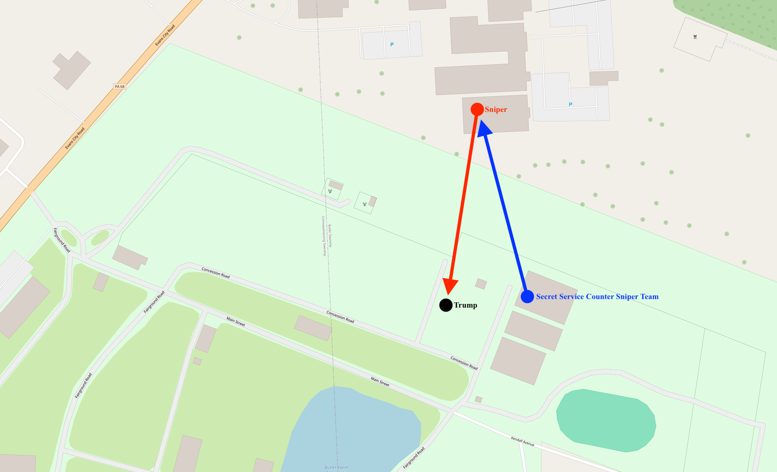
English: A map diagram illustrating the locations of the attacker, Donald Trump, and the Secret Service Counter Assault Team |
|||
| ဝၼ်းထီႉ | ||||
| ငိူၼ်ႈငဝ်ႈတိုၼ်း | openstreetmap.org | |||
| Creator |
OpenStreetMap contributors |
|||
| ၶေႃႈလူတ်းပွႆႇ (ၶိုၼ်းၸႂ်ႉ ၾၢႆႇဢၼ်ၼႆႉ) |
OpenStreetMap data is available under the Open Database License (details). Standard style map tiles are licensed as ODbL Produced Works.
|
|||
| Georeferencing | If inappropriate please set warp_status = skip to hide. |
ပိုၼ်းၾၢႆႇ
တဵၵ်းၼိူဝ် ဝၼ်းထိ/ၶၢဝ်းယၢမ်း တႃႇႁၼ်ၾၢႆႇ ၼႂ်းဝၼ်းၼၼ်ႉ
| ဝၼ်းထီႉ/ၶၢဝ်းယၢမ်း | ႁၢင်ႈလဵၵ်ႉ | သႅၼ်းမၼ်း | ၽူႈၸႂ်ႉတိုဝ်း | တၢင်းႁၼ်ထိုင် | |
|---|---|---|---|---|---|
| ယၢမ်းလဵဝ် | 02:35, 14 ၸူႇလၢႆႇ 2024 | | 2,563 × 1,559 (780 KB) | Cyrogigabyte | Uploaded own work with UploadWizard |
လွင်ႈၸႂ်ႉတိုဝ်း ၾၢႆႇ
ၼႃႈလိၵ်ႈ ၵွင်ႉမႃးၸူးၾၢႆႇၼႆႉ:
လွင်ႈၸႂ်ႉတိုဝ်းၾၢႆႇလူမ်ႈၽႃႉ
Wikis ၸိူဝ်းဢၼ်ၸႂ်ႉဝႆႉ ၾၢႆႇဢၼ်ၼႆႉ:
- ၸႂ်ႉဝႆႉ da.wikipedia.org
- ၸႂ်ႉဝႆႉ ga.wikipedia.org
- ၸႂ်ႉဝႆႉ incubator.wikimedia.org
- ၸႂ်ႉဝႆႉ shn.wikipedia.org
- ၸႂ်ႉဝႆႉ simple.wikipedia.org
- ၸႂ်ႉဝႆႉ sv.wikipedia.org
- ၸႂ်ႉဝႆႉ tl.wikipedia.org